Limestone columns have been found on the ocean floor six kilometres from the coast.
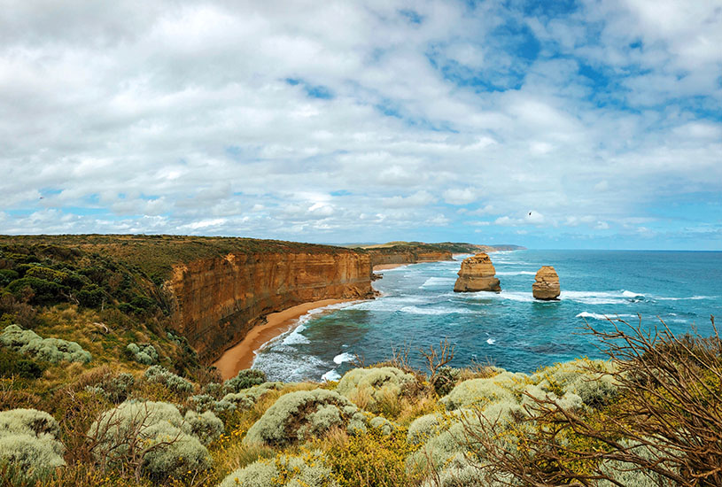
Australia’s iconic tourist attraction, the Twelve Apostles, has received an unlikely boost in numbers, with the discovery of five extra limestone columns hidden deep below the water.
The sea stacks, located 6km offshore from the Twelve Apostles (beside the Great Ocean Road) and 50m beneath the water’s surface, have been revealed during Deakin University’s sonar mapping of the seafloor off Victoria’s southern coast.
Scientists are dubbing them the “Drowned Apostles”.
(Video curtesy of Musuem Victoria)
While the Drowned Apostles are smaller in size than their above-water cousins, their existence alone is remarkable, given their defiance of normal erosion rates.
It is understood to be the first time such limestone stacks have been found preserved in the ocean.
The discovery was made by Deakin University’s Dr Daniel Ierodiaconou, who provided the high-resolution sonar data, and PhD student Rhiannon Bezore and Associate Professor David Kennedy from the University of Melbourne’s School of Geography.
The researchers said that it was “hugely surprising” that any stacks could be preserved at that depth of water and “the pillars should have collapsed and eroded as the sea level rose.”
Like the Twelve Apostles, the newest additions would once have been part of larger limestone sea cliff. Ms Bezore, who made the initial discovery in the sonar data, said the drowned pillars probably date back 60,000 years.
“We had to check what we were seeing because no one has seen stacks submerged at this sea level before,” she said.
Only a very fine balance can create sea stacks, with rock needing to be soft enough to erode quickly from a cliff, but hard enough to support a rocky pillar, Dr Ierodiaconou said.
He explained that details of the rock stacks were revealed through thousands of sonar beams that provided a picture of the sea floor – and the underwater stacks had probably survived because the sea levels must have risen too quickly for waves to erode them tens of thousands of years ago, possibly at the end of an ice age.
Dr Ierodiaconou’s sonar data was collected using the latest advances in multi-beam sonar technology and the team is continuing to fill important knowledge gaps aboard Deakin’s $650,000 research vessel, “Yolla”.
The data is part of a project to map the reef estate in Victoria, which supports commercial fisheries for southern rock lobster and abalone.
[testimonial_text]We are only just starting to understand the biodiversity value of these deep reefs, which harbour diverse invertebrate communities, many unknown to science[/testimonial_text]
[testimonial_picture name=”Dr Daniel Ierodiaconou” details=”Senior Lecturer, School of Life and Environmental Sciences”]
[/testimonial_picture]
Deakin University’s mapping team, led by Dr Ierodiaconou, has been working with Parks Victoria to assess Victoria’s marine park estate. This has included the 12 Apostles Bioscan and, more recently, sonar mapping of Wilson’s Promontory Marine National Park aboard Yolla (3D visualisations).
Discoveries are likely to continue, with a multimillion dollar autonomous underwater vehicle visiting Victoria this week to continue mapping efforts and set up a long-term monitoring site, contributing to Australia’s Integrated Marine Observing system.
Ms Bezore recently presented her research paper at the International Coastal Symposium in Sydney and the findings have been published in the US-based Journal of Coastal Research.